Fisher Peak- Cranbrook - Fort Steele Area

What a beautiful mountain and
scramble! LB/UB lower/upper bowls
View of the upper bowl to the Col

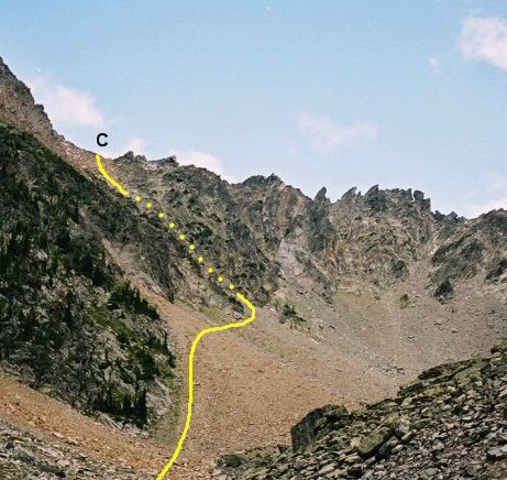
View of steep loose gully to the col

From the col the final slope to the
summit

Last part to the top, see the small
figures in red.

Summit of Mt Fisher
Fisher Peak- Cranbrook - Fort Steele
Area
Scramble: Class 2 û Steep Hiking, Some Use of Hands, Some
Exposure, Some Route Finding
Altitude: 2,846m (9,335 ft)
Elevation Gain: 1,600m (5,250 ft) some
Forest Service Information says 1400m?
Ascent Time: 4 û 5 Hours
Best Season to Scramble: June to September
Highlights
This climb is the scramble of all scrambles in the
Cranbrook, Kimberly, Fort Steele area. Just looking at the peak you know
itÆs a great climb. Highly recommended.
Getting There
It is best to camp the night before in the Kimberley
Cranbrook area. We camped at the Kimberley Riverside Campground which is
between Kimberley and Cranbrook and near Marysville on highway 95. Their
website is www.kimberleycampground.com. From this location you would take
highway 95 to the outskirts of Cranbrook then take highway 93 to the Fort
Steele Historic Park. The road approaches Fort Steele from the south with
Fisher Peak looming in the background. Just past the entrance to Fort
Steele, in less than .5 km you make a right hand turn onto the Wardner-Fort
Steele Road. Follow this for a little over 2 km and take a left onto the
Mause Creek Road. Watch for signs along here directing you to Fisher Peak as
there are a few intersecting roads along the Mause Creek Road which could
cause some confusion. The Mause Creek road winds for approx 8 km up a rough
rocky road to the signed trailhead. You need a high clearance vehicle and
perhaps a 4x4 for the very last part of the road. We made it to within ¢ km
of the trailhead in a mini-van before we said thatÆs far enough. A creek
running across the road had cut a fairly sizable gully in the road. To our
surprise when we made it to the trailhead there were a number of low riding
vehicles there but I canÆt say if they still had mufflers or not.
Route Description
You might want to stretch and warm up a bit at the
trailhead because it is steep and unrelenting right away. From the trailhead
you hike up to the first cirque then follow the trail up the left side of
this cirque to gain the upper cirque. The upper cirque has a beautiful
alpine setting with many large boulders and a bench believe it or not! A
good place to have a snack and view the back of the upper cirque. The trail
leads into the back of the upper cirque and you climb a steep slope on the
left hand side of the cirque up to the col. See the route on the photo here.
From this col you go slightly right then directly up the boulder slope
picking the easiest way. Avoid circling around to the right side of the
mountain from the col as this is not the best route even though there is a
faint trail. This upper part of Fisher is like a teepee so your route will
lead to the summit point. If you find yourself on a route which has exposure
you are likely off-route and should retrace your steps and pick a better
line. The last 15 minutes to the summit does have a couple of spots with
some exposure but if you study them carefully and pick the best way you
should be okay. The summit is very small but the views are fantastic. Return
the same way.
